(Illustrative photo:SGGP)
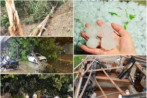
At noon of June 3, torrential downpours hit the Mekong Delta provinces and cities of Soc Trang, Tien Giang, Ben Tre, Kien Giang, Hau Giang, Tra Vinh, Can Tho and Long An on the large scale with average rainfalls of 20- 40 mm.
According to the Southern Regional Meteorology and Hydrometeorology Station, storm Choi-Wan was centered at the southwest of the Philippines' Luzon Island with a maximum wind of up to 75 kilometers an hour.
It is forecast that the storm will enter the East Sea and cause thundery showers and rough sea in the northern territorial waters of the East Sea.