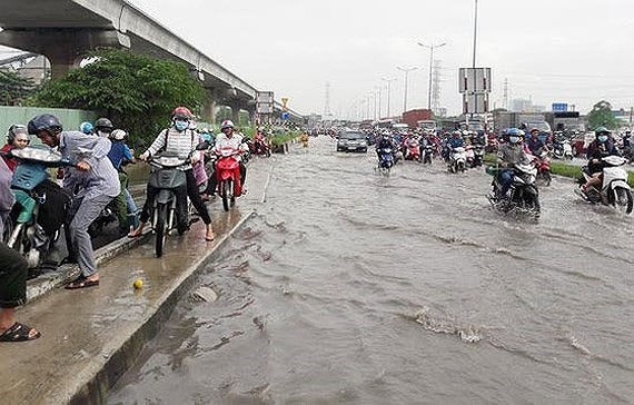
He made the statement in an interview with Sai Gon Giai Phong Newspaper after the city suffered severe flooding consequences in the aftermath of typhoon Usagi.
Southern development plan not respected
Estimating the flooding status in HCMC under the influence of typhoon Usagi which is the 9th storm in the East Sea this year, Professor Nguyen Trong Hoa said that was a several hours long lasting torrential rain which did cause flooding not only in HCMC but also in Vung Tau city and other localities. However, if HCMC had better performed urban management, flooding should have not been as heavy as like that.
In many reports, HCMC itself estimates that urban management has showed many problems and failed to catch up with development demand.
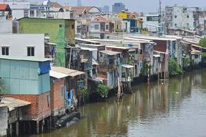
Although many plans have been approved for the last 30 years, urban development management model has been unclear in the city especially in suburban districts. It has majorly been like “oil slick”. Newly established residential areas have been built in the city’s outskirts with incomplete drainage system. They have become “dykes” or “sunken areas” hindering natural water drainage in the city and creating flooding in low lying areas.
Worse, canals have been filled up for construction of houses and other works in new residential areas. Afterwards, the city has recognized the problem and made many decisions to prevent river and canal fill-up. However the number of leveled rivers and canals have already been many, so it has been hard restore them.
In the overall plan approved in 1998, HCMC decided to choose south to be one of major development directions in hope for forming a modern urban chain along Nguyen Van Linh street, part of Ring Road No.2 connecting HCMC and the Mekong Delta and the southeastern region.
In 1994, the city assigned Tan Thuan Industrial Development Company to hire American SOM consulting firm to implement urban development plan in the south of the city.
According to the plan, urban development will not encroach rivers and canals system as well as lowlands in the area. Still it has in fact not conformed to the plan. House construction including Phu My Hung new urban area has caused disappearance of many canals and lowlands, the main drainage network of the city. That is the main cause of the city’s heavy flooding.
Mr. Hoa said that river and canal fill-up for construction has taken place in not only the southern part but also other places in the city.
Re-estimating urban development directions
Professor Dr Nguyen Trong Hoa said that anti-flooding operation should start from the city’s determination in changing common construction plan by re-estimating urban development directions, zoning development management and re-building development management mechanism for each zone.
Next the city should re-consider decentralization in management and tighten plan implementation management. Any plan violation must be handled.
In the following step, the city should build up a scheme to implement plans efficiently and feasibly. Basing on approved the city’s overall construction plan, investors have chosen the most profitable parts to carry out their projects with local leaders’ agreement for the last past. For instance, they have chosen to construct buildings and left road construction, green coverage development, water regulation reservoirs building and drainage system upgrading.
The professor prompted the city to rectify the issue. Plan implementation must be carefully calculated, making clear which works should be built first and which later. Norms to arrange this order is the efficiency of works and their impact to the area where they locate and the city’s development. For a long time, people have paid attention to the efficiency of each work without appropriately estimating the work’s impact to the common development of the city. This has created a loophole for investors to select the most profitable work to implement first.
HCMC should carefully review urban development in the southern part of the city and adjust things not according to plan or according to plan but unreasonable and unfeasible in lowlands and regularly flooded areas with weak terrain. The city should look at projects which have not been implemented or little implemented to limit confusion, negotiating with investors and providing them incentives to invest in other places.
The municipal authorities should focus on urban development in high ground and good terrain areas such as the north, northwest and northeast. Road system has not been developed in many places of these areas to lure investors so the city should have special preferential treatment policies to them.
Urban development adapting to nature is the least costly and most sustainable way, he added.
Mr. Hoa suggested the city to expand development space towards connectivity with Dong Nai and Binh Duong provinces and direct investors to these areas for the common development of the region.
HCMC’s rainwater drainage plan has been built in 2002-2003 and outdated while tidal water drainage plan has been established for over 10 years. Hence, Mr. Hoa said that the city should review the two plans and synchronize them with its common construction plan, study and estimate drainage measures for each area to have suitable solutions instead of applying the same one for the entire city.
In addition, the city should restudy population allocation according to location, development requirements and characteristics of each district. Population should concentrate in districts with good geological and hydrographical conditions for urban development. Reasonable population density will contribute in easing pressure for the city’s drainage system.