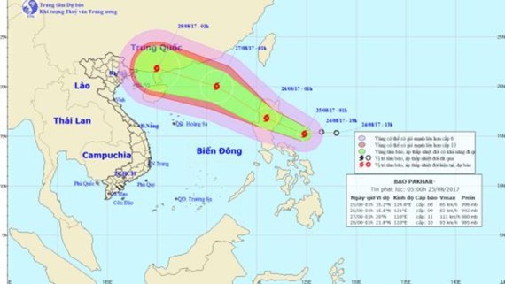
The weather news was issued by the National Hydrology Meteorology Forecast Center.
In the early morning, its eye was located at around 330 kilometers of the east- southeastwards of the Luzon Island with its powerful wind of 60- 75 kilometers an hour.
Storm Pakhar currently moves the west- northwestwards at 15- 20 kilometers per hour.
Within next 24- 48 hours, the tropical storm will move the northwestwards at 25 kilometers.
By 4am tomorrow, it will be at 20.0 degrees north latitude and 116.0 degrees east longitude, at 600 kilometers of the east- southeastwards of the Leizhou Peninsula of China. The strongest wind near the center will gust 100- 115 kilometers an hour.
In next 48- 72 hours, the typhoon will quickly move the west- northwestwards at 25 kilometers an hour.
TAG :
Other news

High risk of drought in central region in next three months

Chilling wave returns Northern region

High tide forecast to exceed alert level 3 in Ho Chi Minh City

Northern region suffers hail phenomenon on large scale

Heavy downpours forecast to hit northern region

Drizzle causes mist & chilly wind in Northern region

Nationwide provinces face high risk of forest fire

Northern region suffers drizzly weather & chilling temperature

Northern & Central regions enjoy sunny days
