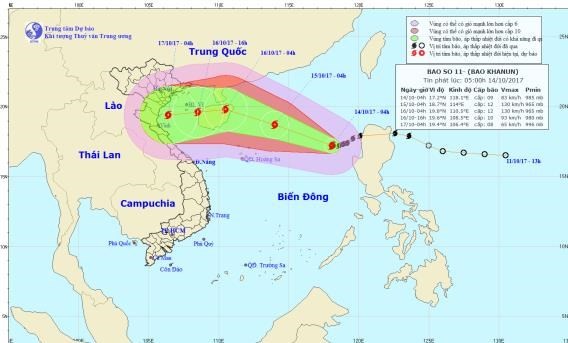
At 4am today, its eye was centered at 17.2 degrees north latitude and 118 degrees east longitude at 660 kilometers of the east- northeastward of the Paracel Island. The strongest wind near the center gusted 67- 90 kilometers.
In next 24 hours, the storm is predicted to move the west- northwestward at 10- 15 kilometers an hour.
By 4am tomorrow, it will be at 18.7 degrees north latitude and 114.0 degrees east longitude at around 280 kilometers of the northeastward of the Paracel Island with its powerful wind of 100- 135 kilometers per hour.
Because of the typhoon influence, the north- East Sea has been effected by heavy rain, wind of level 7-15 and sea rough. The dangerous zone is warned at 14- 21 degrees north latitude and 111 degrees east longitude.
Within next 24- 72 hours, typhoon Khanun is going to move the west- northwestward with a speed of 15 kilometers an hour.
By the early morning of Monday, it will be at 19.8 degrees north latitude and 110.5 degrees east longitude of the Hainan Island (China) with the maximum wind of 115- 135 kilometers an hour. Then, the storm will move the westward at a speed of 15- 20 kilometers per hour.
Its circulation is estimated to cause showery rain, thunderstorm and powerful wind of level 7-8 in the mid and south- East Sea including the Spratly Island, the territorial waters from Binh Thuan to Ca Mau, from Ca Mau to Kien Giang provinces.