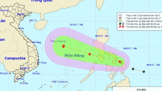
The latest news from the National Hydrology Meteorology Forecast Center showed that the tropical depression was centered at around 12.4 degrees north latitude and 124. 5 degrees east longitude in the eastern territorial water of the Philippines' central area at 10 am today with a wind speed of 40-50 kilometers an hour near the center.
It is going to move the west- northwestward at 20 kilometers per hour and develop stronger in next 24 hours.
By 10am tomorrow, its eye will be at around 13.8 degrees north latitude and 118.9 degrees east longitude at 830 kilometers of the southeastward of the Paracel Islands.
The maximum wind near the center would gust at 40-60 kilometers an hour.

The dangerous zone next 24 hours will be paralleled at 11.5- 14.5 degrees north latitude and 117.0 degrees east longitude.
Within next 24- 48 hours, the tropical depression will continue moving the west- northwestward at a speed of 20 kilometers per hour, and then be able to strengthen into a typhoon.
Around 15.3 degrees north latitude and 114.0 degrees east longitude, at 270 kilometers of the southeastward of the Paracel Islands will be next position of the tropical low pressure system. The strongest wind near the center will reach at 60- 75 kilometers an hours.