By 4pm today, its eye will be located in territorial waters from Quang Binh to Da Nang.
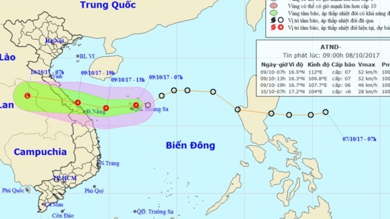
This early morning, the tropical low pressure system was centered at around 450 kilometers of the eastward of the seashore provinces from Quang Binh to Da Nang.
The maximum wind speed near the center gusted 40-60 kilometers an hour.
Within next 12 hours, the tropical depression will move the westward at the speed of 35 kilometers per hour before it is going to make landfall in the provinces.
The maximum wind speed near the center gusted 40-60 kilometers an hour.
Within next 12 hours, the tropical depression will move the westward at the speed of 35 kilometers per hour before it is going to make landfall in the provinces.
By 7pm today, the tropical low pressure system will be centered at seashore provinces of Quang Binh- Da Nang with its powerful wind of 50 kilometers an hour.
Then it will continue quickly moving the westward at 35 kilometers per hour and weaken into a tropical low pressure zone in Thailand.
Then it will continue quickly moving the westward at 35 kilometers per hour and weaken into a tropical low pressure zone in Thailand.
Because of its influence, the north part of East Sea including the Paracel Islands will see showery weather, thunderstorm, sea rough and strong wind of level 6-7.
This afternoon, the Gulf of Tonkin and territorial waters from Thanh Hoa to Quang Ngai including Con Co, Hon Ngu, Ly Son, Cham islands will experience strong wind of level 6-8.
The central coastal provinces from Nghe An, Ha Tinh, Quang Binh, Quang Tri, Thua Thien- Hue and Da Nang will see wind speed of level 6-7.
In the mainland of the provinces from Thanh Hoa to Phu Yen will suffer medium- heavy rain with total rainfall of 100- 150 mm.
By this evening, heavy rainfalls are expected in the central highlands, north-Delta region and provinces of Hoa Binh, Phu Tho, Yen Bai and Son La.


