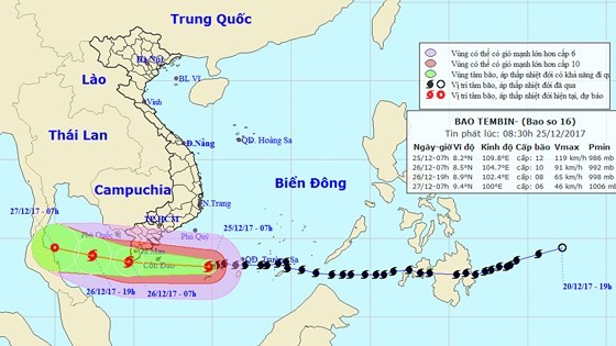
According the latest news from the National Hydrology Meteorology Forecast Center, typhoon Tembin passed through the Spratly and Huyen Tran Islands with a sustainable wind speed of level 13- 15.
At 7am today, it was located at around 320 kilometers of the eastward of the Con Dao Island.
The dangerous zone saw a maximum wind of level 6-9.
Within next 24 hours, the super storm will continue moving the westward at a speed of 20- 25 kilometers an hour.
From this afternoon, the coastal provinces from Ba Ria- Vung Tau to Ca Mau including the Con Dao Island will see wind of level 8-13.
The mainland provinces of Soc Trang, Bac Lieu, Hau Giang and Ca Mau have experienced sustainable wind speed of level 7-10 and at level 6-8 in the southern mainland provinces from Binh Dinh and Binh Thuan.
The coastal provinces from Ba Ria- Vung Tau to Ca Mau are expected to see big waves of 4-6 meters.
Because of the storm circulation and the ongoing cold front, the territorial waters from Quang Ngai to Khanh Hoa have experienced powerful wind of level 6-9, specially the waters of Ninh Thuan, Binh Thuan including the Phu Quy Island have suffered level 7-10 and big waves of 4-6 meters.

By the morning of Wednesday, its eye is mapped at around 9.4 degrees north latitude and 100.0 degrees east longitude of the Gulf of Thailand, and at around 380 kilometers of the west- northwestward of the Tho Chu Island. The strongest wind near the center could gust 40- 50 kilometers an hour.
The dangerous zone will be paralleled at 7.0- 12.0 degrees north latitude and 105.0 degrees east longitude of the Gulf of Thailand.
From tonight, the south part of the central and mid- central region are warned to experience downpours on the large scale.