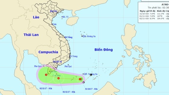
At 7am, its eye was at around the southwestern territorial water of the Spratly Islands.
The depression is predicted to move the westward at 15- 20 kilometers per hour within next 24 hours,
By 7am tomorrow, it will be located at 290 kilometers of the east southeastward of the coastal provinces from Ben Tre to Ca Mau. The highest wind near the center could gust 40-60 kilometers an hour.
Because of its influence in combination with a cold front, the southwestern territorial waters of the Spratly Islands, the southern waters from Binh Thuan to Ca Mau including Phu Quy and Con Dao islands will suffer showery weather, cyclone, thunderstorm, waterspout, strong wind of level 6-9, big wave of 2-4 meters and sea rough.
The southern coastal provinces are warned to experience flood tide.
The dangerous zone will parallel at 5-10 degrees north latitude and 105- 112 degrees east longitude in the next 24 hours.
From October 31 to November 2, the depression circulation is predicted to cause medium- heavy rains in the southern region with its peak rainfall of 100- 200 mm.
The central and south part of the central provinces continue suffering medium- heavy rains and thunderstorms on the large scale. The highest rainfall in the areas will reach at 50- 150 mm, even up to over 200 mm in Quang Nam, Quang Ngai and Binh Dinh.
Currently, a new tropical low pressure zone has just appeared in the eastward of the central part of the Phillippines.
 At 7am, it was located at 6- 7 degrees north latitude, 130- 131 degrees east longitude at 1,200 kilometers of the eastward of Palawan Island.
By November 2, the tropical low pressure zone is going to move the westward at 20 kilometers an hour and is expected to enter the East Sea.