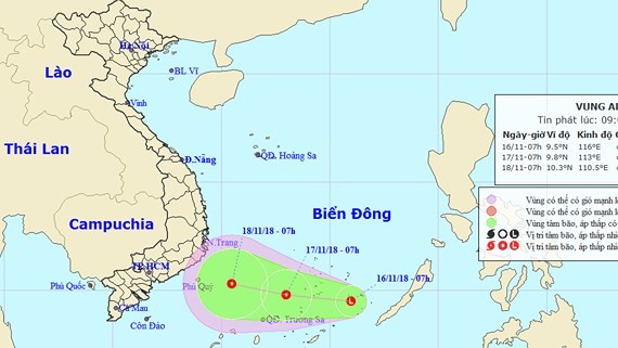
This morning, it was located at around 9- 11 degrees north latitude and 115.5- 116.5 degrees north longitude in the eastern territorial water of the Spratly Islands.
In next 24 hours, the system will move the westwards at a speed of 10- 15 kilometers, and it is expected to develop into the depression.
By 7am tomorrow, its eye will be at around 9.8 degrees north latitude, 113 degrees east longitude, at around 180 kilometers of the northeastward of the Spratly Islands with its maximum wind of 40- 50 kilometers an hour, even gusting above level 8.
Because of the depression circulation, both mid and south parts of the East Sea including the Spratly Islands will get caught in threats of downpour, thunderstorms, gusty winds of level 5-8 and sea rough.
Within next 24- 48 hours, the depression is predicted to continue moving the westwards at 10- 15 kilometers an hour.
By the early morning Sunday, the depression will be centered at around 10.3 degrees north latitude and 110.5 degrees east longitude, at around 170 kilometers towards the East. The maximum wind near the center could hit 40- 60 kilometers an hour.